


16,550
社区成员
 发帖
发帖 与我相关
与我相关 我的任务
我的任务
 分享
分享


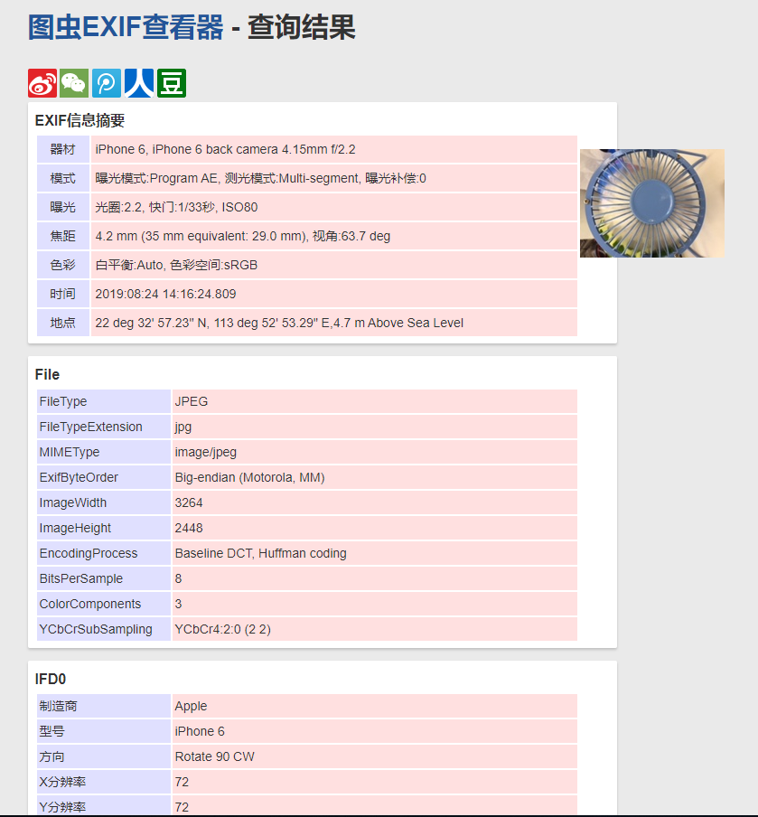
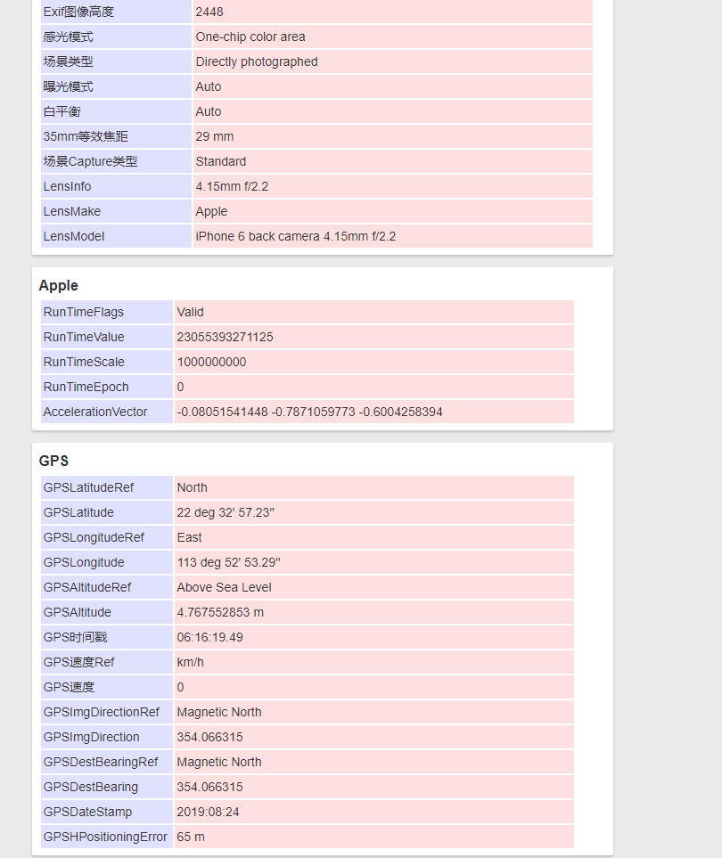 接下来上代码获取,用的是MFC的GDI+相关的图片接口:
	Image* pImg = Image::FromFile(_T("F:\\多媒体素材\\Photos\\IMG_0166.JPG"), FALSE);
	if (pImg) {
		PropertyItem* propertyItem = NULL;
		UINT size = pImg->GetPropertyItemSize(PropertyTagGpsLatitudeRef);
		if (size) {
			propertyItem = (PropertyItem*)malloc(size);
			if (propertyItem) {
				Status stGet = pImg->GetPropertyItem(PropertyTagGpsLatitudeRef, size, propertyItem);
				if ((stGet == Status::Ok) && (propertyItem->value)) {
					char* pValue = (char*)propertyItem->value;//注意这里,不同的属性强转的类型也不同
				}
				delete propertyItem;
				propertyItem = NULL;
			}
		}
		delete pImg;
		pImg = NULL;
	}
#define PropertyTagGpsVer             0x0000
#define PropertyTagGpsLatitudeRef     0x0001
#define PropertyTagGpsLatitude        0x0002
#define PropertyTagGpsLongitudeRef    0x0003
#define PropertyTagGpsLongitude       0x0004
#define PropertyTagGpsAltitudeRef     0x0005
#define PropertyTagGpsAltitude        0x0006
#define PropertyTagGpsGpsTime         0x0007
#define PropertyTagGpsGpsSatellites   0x0008
#define PropertyTagGpsGpsStatus       0x0009
#define PropertyTagGpsGpsMeasureMode  0x00A
#define PropertyTagGpsGpsDop          0x000B  // Measurement precision
#define PropertyTagGpsSpeedRef        0x000C
#define PropertyTagGpsSpeed           0x000D
#define PropertyTagGpsTrackRef        0x000E
#define PropertyTagGpsTrack           0x000F
#define PropertyTagGpsImgDirRef       0x0010
#define PropertyTagGpsImgDir          0x0011
#define PropertyTagGpsMapDatum        0x0012
#define PropertyTagGpsDestLatRef      0x0013
#define PropertyTagGpsDestLat         0x0014
#define PropertyTagGpsDestLongRef     0x0015
#define PropertyTagGpsDestLong        0x0016
#define PropertyTagGpsDestBearRef     0x0017
#define PropertyTagGpsDestBear        0x0018
#define PropertyTagGpsDestDistRef     0x0019
#define PropertyTagGpsDestDist        0x001A
#define PropertyTagGpsProcessingMethod 0x001B
#define PropertyTagGpsAreaInformation 0x001C
#define PropertyTagGpsDate            0x001D
#define PropertyTagGpsDifferential    0x001E
//---------------------------------------------------------------------------
// Property Item
//---------------------------------------------------------------------------
class PropertyItem
{
public:
    PROPID  id;                 // ID of this property
    ULONG   length;             // Length of the property value, in bytes
    WORD    type;               // Type of the value, as one of TAG_TYPE_XXX
                                // defined above
    VOID*   value;              // property value
};

//---------------------------------------------------------------------------
// Image property types
//---------------------------------------------------------------------------
#define PropertyTagTypeByte        1
#define PropertyTagTypeASCII       2
#define PropertyTagTypeShort       3
#define PropertyTagTypeLong        4
#define PropertyTagTypeRational    5
#define PropertyTagTypeUndefined   7
#define PropertyTagTypeSLONG       9
#define PropertyTagTypeSRational  10


